PROJ Y Casting
  PROJ Y WOF
  Lunar Bikepacking
  Prospectus
  The Dead Reckoning Book
  starter pack
  Bikepacking 101
  Dead Reck is Dead
  Introduction
  Day 01
  Day 02
  Introduction
  Day 01
  Day 02
  Day 03
  Introduction
  Day 01
  Day 02
  Day 03
  Day 04
  Day 05
  Day 06
  Introduction
  Day 01
  Day 02
  Day 03
  Day 04
  Introduction
  Day 01
  Day 02
  Day 03
  Introduction
  Day 01
  Day 02
  Day 03
  Introduction
  Day 00
  Day 01
  Day 02
  Day 03
  Day 04
  Instagram Symposium
  Introduction
  Day 00
  Day 01
  Day 02
  Day 03
  Day 04
  Day 05
  Day 06
  Day 07
  Introduction
  Day 00
  Days 01-02
  Day 03
  Day 04
  Day 05
  Day 06
  Days 07-08
  Day 09
  Lord Nerd Beta
  Base Camp: Motel on Carroll, Dunedin
  Day 01: Dunedin to Danseys Inn
  Day 02: Danseys Pass to Ida Railway Hut
  Day 03: Ida Railway Hut to Omarama Pass
  Day 04: Omarama to Huxley Forks
  Day 05: Huxely Forks to Brodrick Pass
  Day 06: Brodrick Pass to Wanaka
  Lord Nerd Beta
  Preface
  Day 01: Charazani to Hichocollo
  Day 02: Hichocollo to Pelechuco
  Day 03: Pelechuco to Mountainside Bivouac #1
  Day 04: Mountainside Bivouac #1 to Hilo Hilo
  Day 05: Hilo Hilo to Mountainside Bivouac #2
  Day 06: Mountainside Bivouac #2 to Curva
  Outro
Outro  Lord Nerd Beta
  Day 01: Oasis to Bishop
  Day 02: Bishop to North Lake
  Day 03: North Lake to Piute Pass and Back to Piute Lake
  Day 04: Piute Lake to Bishop
  Day 05: Mono Hot Springs
  Lord Nerd Beta
  Day 00: The Approach
  Day 01: Tyax Lodge to Iron Pass
  Day 02: Iron Pass to Graveyard Valley
  Day 03: Graveyard Valley to Trigger Lake
  Day 04: Trigger Lake to Tyax Lodge
  Flooded with Feeling
  Wilderness
  Mike Cherney on Black Bears
  Rope Swing
  Slash Piles
  Nylon
Nylon  Conversations with a Black Bear
  US Route 93
  Turnagain Mud Flats
  Bushwhacking in British Columbia
  Men’s Penury
  Bob Dittler et. al.
  Bushwhacking in the MSOJ
  Mike Cherney’s Knife
  Hideout, UT
  Hoover Dam
  Shoe Tree
  Destruction
  The Siskiyou Mountain Club
  Coral Pink Sand Dunes State Park
  EN 417 – Normes Européennes 417 – The Lindal Valve
  Wolf Satellite
  Itchy and Scratchy
  Tanoak Dust
  Lake Havasu
  Knife Fighting
  The Comfort Inn Covenant
  The Wrong/Right Way To Experience Montauk
  Ohiopyle Falls
  Allosaurus via Lean-to
  Lyle Ruterbories, Glacier National Park Ranger
  Water Interface Experimentation (WIE)
  OSOs & UOSOs e.g., Mt. Oberlin
  Louisiana Custom Cars
  Archaeologizing, Pt. II
  Archaeologizing, Pt. I
  Mather Point
  Sarah Plummer Lemmon & Matt Hall
  Kangaroo Lake and Fran
  Minor Religions of the Mt. Shasta Region
  The Fist Bump
  The Ideal Shelter
  Headwaters of the Sacramento River
  Buckle Bunnies
  DFKWA: Baldface Creek - Part I
  Mule Deer Radio Collaring
  The Disappearance of Everett Ruess
  Dall Sheep Kebabs
  The Ideal Woodsman Knife
  DFKWA: Rough and Ready Creek - Part I
  Rowdy Water
  Killing a Mountain Caribou
  Boredom, Slingshots, and Prairie Dogs
  We Would Like to Visit
  Black Bear Ranch
  Origins
  The Heart of the Klamath
  Skid Town Bicycles
  Low Stress Management
  CLUB MACHO
  Club Macho Ep. 01
  Club Macho Ep. 02
  Club Macho Ep. 03
  Cumberland Permanent
  Iron Goat Permanent
  Natchez Trace Permanent
  Trail of Tears Permanent
  (Dis)Enchanted Rock Permanent
  MSOJ Permanent
  Shorty Peak Lookout
  Deer Ridge Lookout
  Arid Peak Lookout
  Flag Point Lookout
  Umpqua Hot Springs
  Cougar Hot Springs
  Bagby Hot Springs
  Goldbug Hot Springs
  Ft. Bridger Rendezvous
  Corndoggin’ Castle Lake
  Kangaroo Lake
  The Narrows
  Matthews Creek
  Introduction


Sunchuli Pass: Day Two
SECTION No1
FYI - Addendum One Basic/Assorted Tips
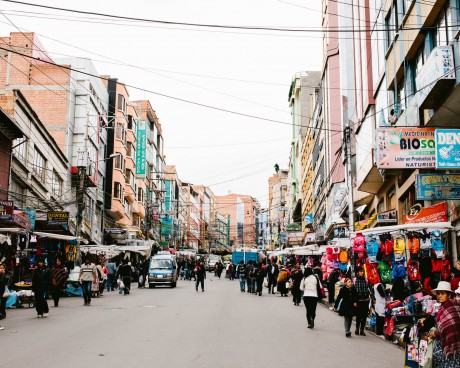
- Plan on having two charges for everything. The agreed upon up front first charge and the surprise, after the fact, bonus charge that is tacked on because you are a tourist.
- Bolivia is majority Catholic country. Be prepared to have everyone look through the photos on your phone. Scrub images from your library before your arrival or expect to have to use your second grade level Spanish to try and explain why you have huge amount of morally questionable selfies and non-selfies.
- The orange piles of flesh being carried around in paint buckets are plucked chickens. We think.
- SERNAP is the real deal. According to Edgar, travelers can stay in any of their offices/outposts/stations for free. Hut to Hut style. However they don’t have online booking, it’s a stumble up to the front door and knock kinda deal.
- Most drivers on the Bolivian Altiplano are pretty cool, give you lots of room, and slow down. Except for this one little punk in a white Ford Fiesta, he will swerve towards you at high speed and spray a tidal wave of brown mud/turd/trash water all over you.
SECTION No2
Campameto Hichocollo - SERNAP Hospitality 14,469 ft
SECTION No3
The Ferocious Teens of Antaquilla 14,950 ft.
SECTION No4
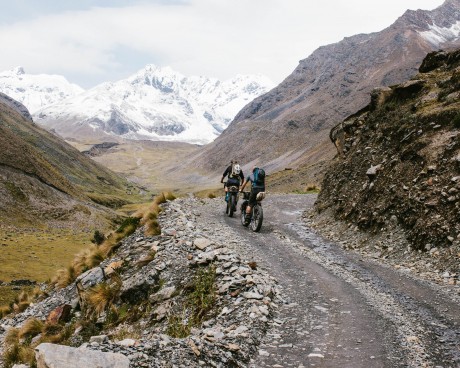
Approach to Pelechuco Pass 15,000 ft. +
SECTION No5
Pelechuco Pass 16,010 ft.
I was just riding along when out of nowhere it hit me like a whippit. The sensation was like… you ever huff paint? Anyway, the road was the same road we’d been on for the last two days. Sure, yeah, we’d been gradually climbing but not really and besides today was supposed to be an easy day. A warm-up. Sunchuli Pass, two days from now, that was the Motherfucker.
Three months ago, when we finally decided on Bolivia because Colombia was going to be too wet and Argentina was going to be too boring, and because Bolivia had this mining problem, a byproduct of which is a vast network of physics-defying roads, I thought about the elevation. I think I remember saying something at the time like, “Hey guys those mountains are tall, like really tall.” And that was that until two weeks ago, when we really started planning and packing for Bolivia I thought about it and talked about it some more.
I even did some research, the gist of which was that if you can avoid getting altitude sickness you should because it’s uncomfortable and possibly deadly.”- DWP;Like with everything (car washes, diseases, insurance plans, burritos, etc.) there are levels. The first level, your basic run of the mill hypobaropathy or soroche, just causes fatigue, dizziness, lightheadedness, insomnia, tingles, jingles, shortness of breath, drowsiness, General Malaise11What a great name!!!! For like a G.I. Joe character or something!, nosebleeds, rapid pulse, and “excessive” farts. The next level is more dangerous. So dangerous in fact that several of the more common conditions have acronyms, e.g HAPE (high altitude pulmonary edema) and HACE (high altitude cerebral edema). I didn’t do a lot of research though because after reading all about the symptoms and causes of altitude sickness I came to the prevention section and it was empty. It basically said, “Don’t suck.” Apparently the best way to prevent and/or avoid altitude sickness was to be genetically superior. Also, just like allergies, altitude sickness can come and go, and come right back. Oh, and one last thing, there is no way to predict the effects on you, at any particular time or age. It just be what it be. Maybe you get HAPEed, maybe you don’t.
In fact the only thing you can do to mitigate the effects is to ascend to higher elevations gradually, in stages. So like, the only real advice the internet has is… walk up or drive up but definitely don’t fly up. And but because El Alto International Airport is located 13,799 feet above sea level,
- We didn’t land so much as “dock.” It’s almost like we took off from Miami, climbed to our flying altitude, went south towards a big mountain with a tarmac on top, and pulled into the tarmac much like a car pulls into driveway—it just makes a turn and stops.
- We did not ascend to higher elevations gradually. We did the opposite. Basically we strapped ourselves to a rocket and rode it to space.
You land, you taxi, you come to a stop and the plane powers off. The second the plane is all the way off and the pressurized cabin is no longer pressurized, you’re fucked. Instantaneously you feel 70% heavier, dumber and slower. And gassier. But then you descend to La Paz and you walk around, and you get your bearings, and 24 hours goes by and you normalize. Your new normal kinda sucks, like having a hangover and the bends at the same time. But other than that, and the insomnia, you’re good to go. At least physically and mentally.
Emotionally though, elevation was a constant consideration. Especially because all we did was go places and make plans to go to other more places.”- DWP;Everyday, all day long, every chance we had, we asked locals:
- How high is that pass?
- Is this pass higher than that pass?
- What elevation is this town at?
- What elevation are we at now?
And we talked among ourselves:
- Did you sleep last night?
- Is Charazani higher than La Paz?
- What elevation did we sleep at last night?
- What elevation are we sleeping at tomorrow night?
- How tall is Sunchuli?
- Is Sunchuli the tallest pass?
- What’s the average elevation of the Altiplano?
- Did you just fart?
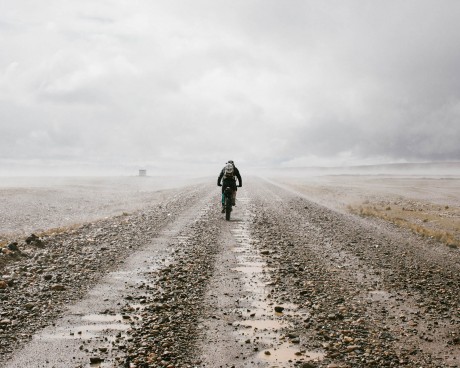
Anxiety and preoccupation aside, and except of course for the constant low-grade feeling of mailasment, so far, the last two days were a lot like bikepacking. Sure, yesterday we rode for seven hours across the Altiplano in the kind of weather one associates with Jupiter. And we did come upon way more towns than expected. And were surrounded by more Turds, Trash and Mud than expected. But there were roads, and people and mountains and all of our shit was strapped to our bikes soo…
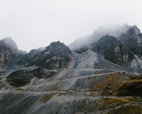
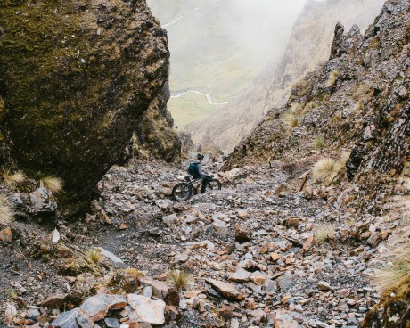
Then about 2k from the top of Pelechuco Pass it hit me. I was just riding along when suddenly I felt dizzy and confused, and I just kinda fell off my bike a little bit. Also, my heart was beating unreasonably fast.”- DWP;So I spit out my coca leaf and started push-walking my bike instead of riding it. Figuring that maybe what happened was I suck at riding my bike over 15,000 foot mountains. Then it started snowing, and the headwind which had been gnarly for the last thirty minutes started throwing rocks and sand, and icicles, at my face. That’s when I realized I was preternaturally hungry. And out of water. Also, it’s at about that time the first of many nearly-debilitating anxiety attacks attacked me.
Just to be clear:
- We were in a blizzard.
- We were 15,000 feet above sea level and climbing.
- I was super-duper hungry.
- And I was confused, dizzy and suffering from disorganized thinking.
- And I was in the midst of a pretty wicked anxiety attack.
- And I was panting.
- And the temperature was dropping.
- Oh, and at this point we were FULLY committed. Turning around wasn’t really an option and the fastest way down—and I needed to go down, immediately—was straight ahead.
Which speaking of which, all mountaintops are by definition slow to come. That’s what mountaintops do, they dole themselves out slooooooooowwwwwwwlly. If you want to get over them you have to haul them in, like a trophy marlin. Using, in my case, an eight year old child’s arms. But this fucking thing was ridiculous. I felt like Frodo, if Frodo had to deliver a highly specialized mountain bike instead of throw away a piece of dangerous jewelry. One step at a time. For what felt like hours. In a fucking whiteout. I would have taken photographs but at the time I seriously thought I was going to
- die.
- go crazy.
- start crying.
- freeze to death.
- pass out.
- never see my kids again.
So I didn’t take any photographs. I just mumbled and stumbled my way past the lake, to the cross built into the rock wall marking the summit, then down the other side. I’ll leave you with these three thoughts:
- I have a running tally (in my brain mind) of the photographs that “got away.” This is a very special list for very special photographs. I go for weeks and months and even years without adding to this list. And sometimes when the light is right I might add two moments to the list in just one afternoon. The shit I saw on that mountaintop. The blizzard light at 15,000 feet. I missed no fewer than five photographs that afternoon. Maybe more.
- I NEVER WOULD HAVE MADE IT OVER THAT FUCKER without Kyle and James. The physical/mental/emotional/spiritual assistance I required was pretty fucking serious. Also, I’m sure those fuckers were taxed as well. Or maybe not. Whatever. I’m alive because of them.
- The road down the backside of Pelechuco Pass is the most remarkable and spectacular road in the world. I stake my life on it. That I was frozen and in no state to enjoy myself, on what was/is/and forever will be the wickedest descent ever, is tragic.
SECTION No6
Pelechuco 11,787 ft.
DILLON MAXWELL EARNED A BA IN HISTORY FROM COLORADO STATE UNIVERSITY. HE WROTE HIS THESIS ON THE SPANISH CIVIL WAR'S EFFECTS ON THE CUBAN REVOLUTION AND DID HISTORICAL FIELDWORK IN SOUTHERN COLORADO FOCUSING ON FAMED AMERICAN EXPLORER ZEBULON PIKE AND THE ENVIRONMENT PIKE ENCOUNTERED IN HIS TRAVELS. DILLON LIVES IN FORT COLLINS, COLORADO WHERE HE SPENDS HIS TIME RIDING BIKES, CAMPING, RIFFIN', AND PLAYING DRUMS. Brief Histories: Pelechuco by Dillon Maxwell
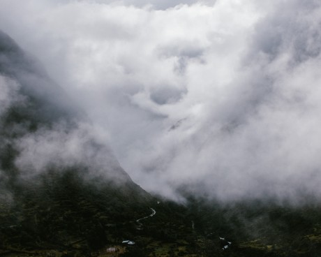
Nestled in the heart of the Cordillera Apolobamba is the small town of Pelechuco. The name comes from the Quechua Phuyu Kuchu, meaning “cloudy corner.” Pelechuco is an exemplar of how globalization can reach into unseemingly far off places. The town has not been spared from the ravages of exploration, colonialism, and adventure perpetrated by those from faraway lands.
The area was originally inhabited by the Mollo peoples and later by the Incans. Though no large scale settlements were set up in the present day area, small scale archeological sites can be found outside of Pelechuco.
The town of Pelechuco itself was founded in the 1560’s by Jesuit Priests. The Spanish used the town because it sits at a crossroads for travelers and traders in the area. The cultural landscape of Pelechuco reflects this Spanish influence. An old Catholic Church made of stone, a town square, and cobble streets dominate much of the cultural landscape. For 300 plus years, the small town experienced a cultural syncretism, blending Aymara, Quechua, and Spanish influence.
Another culture got thrown into the mix in the early 1900s when a German mining mogul, Karl Francke, made his way to Pelchuco. Francke was part of the Aramayo-Francke Mining Company, Bolivo-Germanic mining venture specializing in tin, gold, and wolfram. The company was based in England, then moved to Geneva to dodge a lofty British tax imposition. In the town’s square, Franck added a wrought-iron fountain in the town’s square and large stone house, in which Francke resided. Leading one to wonder if Francke used the tax money he saved from dodging British tax to set up his residence and town square in Pelechuco in order to create his lasting legacy on the town.
Francke has also been tied to the famed British adventurer, archeologist, and explorer, Colonel Percy Fawcett. Fawcett’s fame comes from his exploration of Latin America in search for the “Lost City of Z,” in addition to his survey work of the Brazilian-Bolivian border. Fawcett is documented as staying in the Pelechuco on several occasions with Francke hosting him and his expedition.