PROJ Y Casting
  PROJ Y WOF
  Lunar Bikepacking
  Prospectus
  The Dead Reckoning Book
  starter pack
  Bikepacking 101
  Dead Reck is Dead
  Introduction
  Day 01
  Day 02
  Introduction
  Day 01
  Day 02
  Day 03
  Introduction
  Day 01
  Day 02
  Day 03
  Day 04
  Day 05
  Day 06
  Introduction
  Day 01
  Day 02
  Day 03
  Day 04
  Introduction
  Day 01
  Day 02
  Day 03
  Introduction
  Day 01
  Day 02
  Day 03
  Introduction
  Day 00
  Day 01
  Day 02
  Day 03
  Day 04
  Instagram Symposium
  Introduction
  Day 00
  Day 01
  Day 02
  Day 03
  Day 04
  Day 05
  Day 06
  Day 07
  Introduction
  Day 00
  Days 01-02
  Day 03
  Day 04
  Day 05
  Day 06
  Days 07-08
  Day 09
  Lord Nerd Beta
  Base Camp: Motel on Carroll, Dunedin
  Day 01: Dunedin to Danseys Inn
  Day 02: Danseys Pass to Ida Railway Hut
  Day 03: Ida Railway Hut to Omarama Pass
  Day 04: Omarama to Huxley Forks
  Day 05: Huxely Forks to Brodrick Pass
  Day 06: Brodrick Pass to Wanaka
  Lord Nerd Beta
  Preface
  Day 01: Charazani to Hichocollo
  Day 02: Hichocollo to Pelechuco
  Day 03: Pelechuco to Mountainside Bivouac #1
  Day 04: Mountainside Bivouac #1 to Hilo Hilo
  Day 05: Hilo Hilo to Mountainside Bivouac #2
  Day 06: Mountainside Bivouac #2 to Curva
  Outro
Outro  Lord Nerd Beta
  Day 01: Oasis to Bishop
  Day 02: Bishop to North Lake
  Day 03: North Lake to Piute Pass and Back to Piute Lake
  Day 04: Piute Lake to Bishop
  Day 05: Mono Hot Springs
  Lord Nerd Beta
  Day 00: The Approach
  Day 01: Tyax Lodge to Iron Pass
  Day 02: Iron Pass to Graveyard Valley
  Day 03: Graveyard Valley to Trigger Lake
  Day 04: Trigger Lake to Tyax Lodge
  Flooded with Feeling
  Wilderness
  Mike Cherney on Black Bears
  Rope Swing
  Slash Piles
  Nylon
Nylon  Conversations with a Black Bear
  US Route 93
  Turnagain Mud Flats
  Bushwhacking in British Columbia
  Men’s Penury
  Bob Dittler et. al.
  Bushwhacking in the MSOJ
  Mike Cherney’s Knife
  Hideout, UT
  Hoover Dam
  Shoe Tree
  Destruction
  The Siskiyou Mountain Club
  Coral Pink Sand Dunes State Park
  EN 417 – Normes Européennes 417 – The Lindal Valve
  Wolf Satellite
  Itchy and Scratchy
  Tanoak Dust
  Lake Havasu
  Knife Fighting
  The Comfort Inn Covenant
  The Wrong/Right Way To Experience Montauk
  Ohiopyle Falls
  Allosaurus via Lean-to
  Lyle Ruterbories, Glacier National Park Ranger
  Water Interface Experimentation (WIE)
  OSOs & UOSOs e.g., Mt. Oberlin
  Louisiana Custom Cars
  Archaeologizing, Pt. II
  Archaeologizing, Pt. I
  Mather Point
  Sarah Plummer Lemmon & Matt Hall
  Kangaroo Lake and Fran
  Minor Religions of the Mt. Shasta Region
  The Fist Bump
  The Ideal Shelter
  Headwaters of the Sacramento River
  Buckle Bunnies
  DFKWA: Baldface Creek - Part I
  Mule Deer Radio Collaring
  The Disappearance of Everett Ruess
  Dall Sheep Kebabs
  The Ideal Woodsman Knife
  DFKWA: Rough and Ready Creek - Part I
  Rowdy Water
  Killing a Mountain Caribou
  Boredom, Slingshots, and Prairie Dogs
  We Would Like to Visit
  Black Bear Ranch
  Origins
  The Heart of the Klamath
  Skid Town Bicycles
  Low Stress Management
  CLUB MACHO
  Club Macho Ep. 01
  Club Macho Ep. 02
  Club Macho Ep. 03
  Cumberland Permanent
  Iron Goat Permanent
  Natchez Trace Permanent
  Trail of Tears Permanent
  (Dis)Enchanted Rock Permanent
  MSOJ Permanent
  Shorty Peak Lookout
  Deer Ridge Lookout
  Arid Peak Lookout
  Flag Point Lookout
  Umpqua Hot Springs
  Cougar Hot Springs
  Bagby Hot Springs
  Goldbug Hot Springs
  Ft. Bridger Rendezvous
  Corndoggin’ Castle Lake
  Kangaroo Lake
  The Narrows
  Matthews Creek
  Introduction


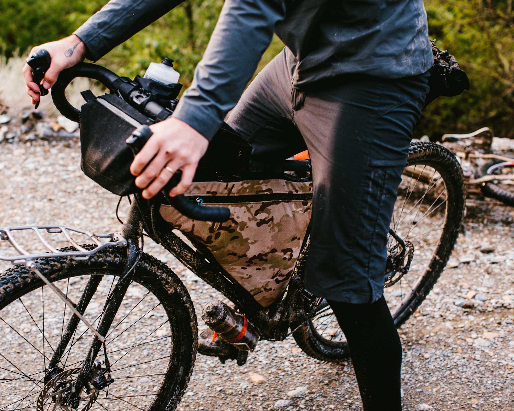
Piute Pass: Day 01
SECTION No1 Day 01 Basic Info
START
Oasis, California
STOP
Bishop, California
DISTANCE
53.6 miles
ELEVATION GAIN
7361 feet
WEATHER
Scorching hot, freezing rain, blue bird skies on fresh fallen snow.
GOAL
Leave Oasis heading east to ride over the White Mountains to Bishop, if possible we would add a bonus section through the Bristlecone Pine Forest and down Silver Canyon into Bishop.
REALITY
We rode over the White Mountains and we did the bonus section. In the morning it was really hot, then it got really really cold with junior varsity snow (i.e. rain at 32 degrees) coming down on us.
SECTION No2 A Tolerable Level of Misery
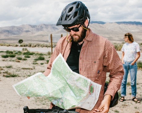
Oasis doesn’t look the way it’s supposed to. If you’re going to name a place Oasis there are certain expectations; maybe I’ve been inculturated by Scheherazade and Looney Toons, so what? When I think of an oasis, I’m thinking about palm trees, lapping blue waters, swaying hammocks, genies and coconut cocktails delivered by chilled out turtles in sunglasses and palm frond caps; you know, the works. This Oasis had none of that, no genies, nada. It is just an intersection of two roads, some fences, a few trees, and a shot-out camper I am sure has seen its fair share of tequila-fueled self-destruction. Aside from that there wasn’t much of an oasis in Oasis. We weren’t planning to hang around anyway, Oasis is where the eastern section of the 168 starts/ends and where we started our ride.
We spent the previous night in Brown’s Town Campground, an RV park just outside of Bishop. We slept under the stars, kinda falling asleep under the undying blue light of the moon. This was the high desert in late May, and we were sacked out deep inside the rain shadow of the Sierra Nevada. Normally there would be no reason to expect any evening precipitation, but this was a Yonder Journal trip, and seasonally incorrect weather is part of our M.O., so in the middle of the night when it started to sprinkle on us it was a non-surprise surprise. The rain was rascally and continued just long enough to wake us up and send us rifling through our gear to set up some makeshift tarps. Most of the crew set up something slightly professional, but I just pulled out my tent’s rain fly and rolled myself into it.
We arrived in Oasis around 10:00 AM the following morning under a vengeful sun irradiating the countryside. Outside of the few trees in the immediate vicinity, the rest of the landscape was scorched earth: baked chalky hills quilted with dimpled sagebrush. We unloaded the van, screwed with our bikes, took photographs, made jokes and set off pedaling in a dead-still dry heat. No wind, no help. The road leaving Oasis ran directly into the hills to the west where it disappeared.
This was like riding in a sauna, and the heat weighed on us like a great cloak, suffocating any ambition.”- KVH;Thankfully the climb was short and our legs were fresh so it wasn’t too long before we reached Gilbert Summit at 6374 feet. From there we looked down on Deep Springs Valley and across to the White Mountains in the west.
As we pedaled, the layers of clothing we had buried deep in our bags during the first climb were dug back out. We were hit by the first series of short showers just as the wind and the grade began to pick up, serving us a chilling wind/water combo that only a few hours before would have been a godsend. Now it served to remind us of our lack of sufficient clothing. As we climbed into the canyon leading up to Westgard Pass we came across a motorcycle accident. A totaled black Honda Goldwing was piled onto the back of a flatbed tow-truck and by the time we arrived the rider had already been taken away, there was no indication of his condition. Three shocked riders stood away from their parked bikes scratching at the ground while they stared with glossed eyes at the crowd of motorists, the car-choked road, and the darkening desert.
ADDITIONAL SUPPORT PROVIDED BY SRAMThe climb up the east side of the White Mountains is steep, beautiful, and claustrophobic. The asphalt rolls over natural water bars and through tight openings cut between rock walls. The weather conditions continue to decline and we are splashed with bursts of frigid mountain rain, but the climb passes quickly and we reach the plateau at the top of the range. To strictly follow the 168 we would descend the west side of the Whites into Big Pine and go back up the 395 to Bishop. That would be the short option, the easy option, the smart option. Alternatively we could ride up through the Bristlecone Pine Forest and descend down Silver Canyon. In terms of length the two routes are almost dead even, but the Bristlecone route would take us up to around 11,000 feet, adding another 3,000 feet or so of climbing. With the precipitation giving no hint of letting up it seemed that the right thing to do was to to gain elevation—get above the storm you know?—while steering clear of any services or shelter.
If what we were experiencing earlier in the day could be described as bursts of rain, our afternoon inclement experience through the Bristlecones was a prolonged blast. The weather morphed into a rain/hail tag team; the hail tenderizes the skin, raising sensitivity and creating a higher tactile awareness perfect for magnifying the heat-degrading effects of its partner, the nearly frozen rain. Our pace was slow and forward progress was further interrupted by repeated moments of roadside bivouacking as we took shelter from the downpour beneath the sparse, gnarled canopies of the world’s oldest trees. At the time there was a distinct lack of wonder concerning the existence of these ancient trees.
Bristlecones, if you are out there, we didn’t mean it. We know you’re cool, we know that you’re worthwhile, glorious, and amazing. You just have to understand that when we were there, those cuss words, those cutting remarks and put downs, those weren’t us, that’s not who we are. That was the bad decision talking, the cold bones talking. What I’m trying to say is that it wasn’t you, it was us.”- KVH;At one point I looked over at Dylan who was shivering, his flannel shirt and jean shorts soaked through “You alright bud?” “Yeah, yeah… I’m totally cool.” What sarcasm, what a sense of irony! I am glad he had the grit to stick with the existential humor shtick because none of us had any kind of gear to offer up. This kind of knowing check-in is common during a difficult journey, no one expects to be surprised by the answer, all we are looking for is a vocalization that verifies our shared experience, an agreement that we have all resigned to the point where we share a tolerable level of misery, and that despite our hardship we will continue to remain thoroughly in cahoots.
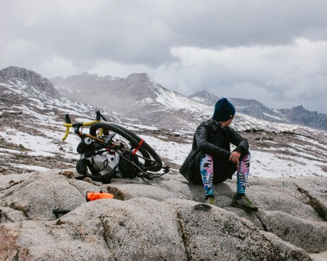
We continued to climb, hoping the visitor center would be open and dreaming of hot chocolate, dry carpet, and an environmentally-controlled user experience catering to human comfort while simultaneously providing a degree of ancient arboreal education. I was so looking forward to an in-depth look at the wonders of phloem and xylem or experiencing a dioramic representation of the golden marmot’s spiritual life. Like most dreams, this one would not come to pass. The visitor center, our sanctuary, was closed. The climb had spread out our merry band and we needed to regroup. In order to keep from freezing as riders straggled in, we did push ups, wrapped ourselves in aluminum foil and laid on the hood of a stranger’s truck, still warm from the long drive up the mountain. From here it was only a few miles to the cutoff where we would catch the Silver Canyon road and plummet down the west side of the Whites.
At this point we were over 10,000 feet above sea level and altitude was randomly attacking our herd. Ty and Erik, two of our strongest, were feeling it the most. Nausea, headaches, shortness of breath. And the bitch of it is that you can’t prepare for it. Not on our budget, at least. The last couple of miles before the descent were the slowest of the day. The road was a mess with snow melting into large, unavoidable puddles.
At this point we were above the clouds, or at least the clouds weren’t above us. The snow muffled sound from our surroundings and the rumble of our tires quickly faded out of recognition. During those moments our path was difficult, quiet, and serene. At the fork before the plunge we gathered in a white field under a bright sun; some of us hacked, some of us wheezed, and together we took in a grand horizon of mountains and clouds stretching away from us like ripples in a pond.”- KVH;
SECTION No3 Oasis


SECTION No4 Gilbert Summit


SECTION No5 Deep Springs Valley


SECTION No6 Ancient Bristlecone Pine Forest


SECTION No7 Silver Canyon


SECTION No8 Riding into Bishop


SECTION No9
Brief Histories Day 01: Oasis to Bishop Researched & Compiled by Dillon Maxwell
HWY 168
- Built in 1934.
- 124 Miles.
- Broken into Two Sections - East(Fresno to Huntington Lake) and West Section (Oasis to Sabrina Lake).
Westgard Pass
- Elevation 7,313 ft.
- Named after Anton L. Westgard, aka “The Pathfinder,” who was commissioned by the Federal Highway Administration in 1911 to scout possible routes for a transcontinental highway.
- Originally built in 1873 by J.S. Broader to get Army troops across to the Inyo and White Mountains.
- “The Narrows” are a section between mile post 28.57-28.65 where their is no center strip painted on the road.
Deep Springs College
- Founded by L.L. Nunn in 1917 to educate men in the West on engineering for the electrical power plants that Nunn had made his fortune on.
- It is a private two-year college.
- Student’s education is directed by the Three Pillars of the School: Academics, Labor, Self-Governance.
- Deep Springs has under 50 people including staff and student.
- Students have to ranch and raise alfalfa hay 20 hours a week and have a large say in what happens in the school as a part of the Self-Governance Pillar.
The White Mountains
- Range on the California-Nevada Borderlands.
- 60 miles in length, 10 miles in width.
- Ecologically Dry.
- Fault-Block Mountain range.
- Highest Point is White Mountain at 14,252 feet.
- The mountains host a fauna population of mustangs, bighorn sheep, marmots, and Clark’s nutcracker.
- Contains great examples of Late Proterozoic and Cambrian Sections.
The Ancient Bristlecone Pine Forest
- Protected Area in the White Mountains.
- Trees there have been dated to about 4000 years old.
- Methuselah Grove is an ancient, unmarked grove in the Bristlecone Pine Forest.
- The Methuselah Grove contains two of the world’s oldest non-clonal living organisms, one being 4789 years old, the other being 5,064 years old.
- The location of these trees is unmarked to keep the location safe from vandals.
- The trees grow in a white, rocky soil called dolomite that has basically weeded out other plants over thousands of years leaving the hearty bristlecones to survive.
- The Patriarch Grove in the Forest contains the world’s largest bristlecone pine.
- These ancient trees grow between 9,800-11,000 feet.
SECTION No10 Route Map
SECTION No11 Mechanical Transport

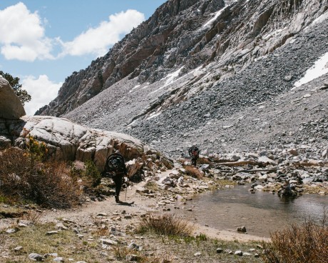
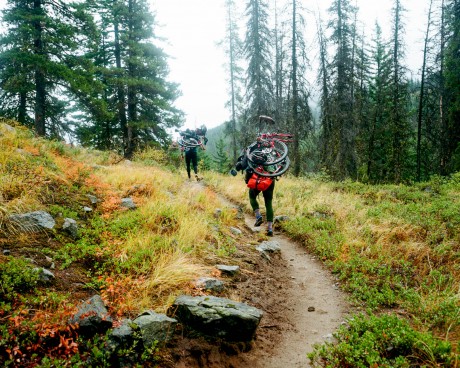
- The purpose of this ride was to travel California Highway 168 from end to end. Not just the 168 as it exists today but the whole thing. The way it was originally imagined, from Nevada to Fresno, over both the Whites and the Sierra. Most of the route is on public roads which is obviously legal and therefore a no-brainer. However, 22 miles of the route is on trail John Muir Wilderness in the Sierra and Inyo National Forests. On which trail and in which Wilderness possession/use of Mechanical Transport is 1000% illegal.
- And so, because using/possessing Mechanical Transport in a Wilderness Area is 1000% illegal, we completely disassembled our bikes: pedals off, wheels off, skewers out, chain off, seat out, etc. Then we semi-permanently attached the component parts to our backpacks where they remained (without exception, even while we slept) for the duration of our time in the Wilderness Area.
- So the question is, if you disassemble a car into thousands of pieces, including the motor, and transport the parts through the Sierra one the back of pack mules, which are legal, is that the same as driving an automobile through a Wilderness Area? We think not, we think if you disassemble a mechanism it’s no longer a mechanism.
- More importantly (semantics aside for a moment), we didn’t ride bikes in the Wilderness, nor are we advocating for others to ride bikes in the Wilderness.
- We took great pains to adhere to the law and the spirit of the Wilderness Act.