PROJ Y Casting
  PROJ Y WOF
  Lunar Bikepacking
  Prospectus
  The Dead Reckoning Book
  starter pack
  Bikepacking 101
  Dead Reck is Dead
  Introduction
  Day 01
  Day 02
  Introduction
  Day 01
  Day 02
  Day 03
  Introduction
  Day 01
  Day 02
  Day 03
  Day 04
  Day 05
  Day 06
  Introduction
  Day 01
  Day 02
  Day 03
  Day 04
  Introduction
  Day 01
  Day 02
  Day 03
  Introduction
  Day 01
  Day 02
  Day 03
  Introduction
  Day 00
  Day 01
  Day 02
  Day 03
  Day 04
  Instagram Symposium
  Introduction
  Day 00
  Day 01
  Day 02
  Day 03
  Day 04
  Day 05
  Day 06
  Day 07
  Introduction
  Day 00
  Days 01-02
  Day 03
  Day 04
  Day 05
  Day 06
  Days 07-08
  Day 09
  Lord Nerd Beta
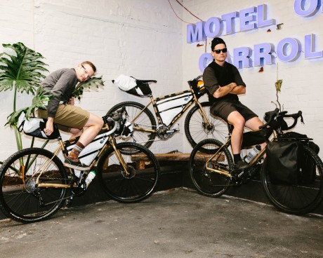
  Base Camp: Motel on Carroll, Dunedin
  Day 01: Dunedin to Danseys Inn
  Day 02: Danseys Pass to Ida Railway Hut
  Day 03: Ida Railway Hut to Omarama Pass
  Day 04: Omarama to Huxley Forks
  Day 05: Huxely Forks to Brodrick Pass
  Day 06: Brodrick Pass to Wanaka
  Lord Nerd Beta
  Preface
  Day 01: Charazani to Hichocollo
  Day 02: Hichocollo to Pelechuco
  Day 03: Pelechuco to Mountainside Bivouac #1
  Day 04: Mountainside Bivouac #1 to Hilo Hilo
  Day 05: Hilo Hilo to Mountainside Bivouac #2
  Day 06: Mountainside Bivouac #2 to Curva
  Outro
Outro  Lord Nerd Beta
  Day 01: Oasis to Bishop
  Day 02: Bishop to North Lake
  Day 03: North Lake to Piute Pass and Back to Piute Lake
  Day 04: Piute Lake to Bishop
  Day 05: Mono Hot Springs
  Lord Nerd Beta
  Day 00: The Approach
  Day 01: Tyax Lodge to Iron Pass
  Day 02: Iron Pass to Graveyard Valley
  Day 03: Graveyard Valley to Trigger Lake
  Day 04: Trigger Lake to Tyax Lodge
  Flooded with Feeling
  Wilderness
  Mike Cherney on Black Bears
  Rope Swing
  Slash Piles
  Nylon
Nylon  Conversations with a Black Bear
  US Route 93
  Turnagain Mud Flats
  Bushwhacking in British Columbia
  Men’s Penury
  Bob Dittler et. al.
  Bushwhacking in the MSOJ
  Mike Cherney’s Knife
  Hideout, UT
  Hoover Dam
  Shoe Tree
  Destruction
  The Siskiyou Mountain Club
  Coral Pink Sand Dunes State Park
  EN 417 – Normes Européennes 417 – The Lindal Valve
  Wolf Satellite
  Itchy and Scratchy
  Tanoak Dust
  Lake Havasu
  Knife Fighting
  The Comfort Inn Covenant
  The Wrong/Right Way To Experience Montauk
  Ohiopyle Falls
  Allosaurus via Lean-to
  Lyle Ruterbories, Glacier National Park Ranger
  Water Interface Experimentation (WIE)
  OSOs & UOSOs e.g., Mt. Oberlin
  Louisiana Custom Cars
  Archaeologizing, Pt. II
  Archaeologizing, Pt. I
  Mather Point
  Sarah Plummer Lemmon & Matt Hall
  Kangaroo Lake and Fran
  Minor Religions of the Mt. Shasta Region
  The Fist Bump
  The Ideal Shelter
  Headwaters of the Sacramento River
  Buckle Bunnies
  DFKWA: Baldface Creek - Part I
  Mule Deer Radio Collaring
  The Disappearance of Everett Ruess
  Dall Sheep Kebabs
  The Ideal Woodsman Knife
  DFKWA: Rough and Ready Creek - Part I
  Rowdy Water
  Killing a Mountain Caribou
  Boredom, Slingshots, and Prairie Dogs
  We Would Like to Visit
  Black Bear Ranch
  Origins
  The Heart of the Klamath
  Skid Town Bicycles
  Low Stress Management
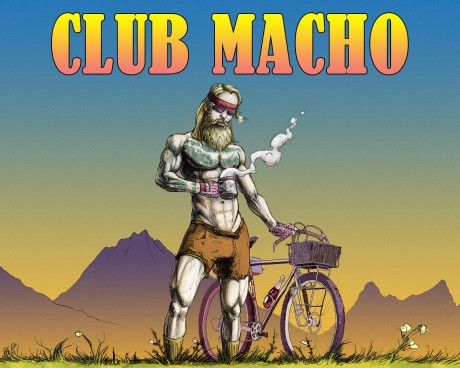
  CLUB MACHO
  Club Macho Ep. 01
  Club Macho Ep. 02
  Club Macho Ep. 03
  Cumberland Permanent
  Iron Goat Permanent
  Natchez Trace Permanent
  Trail of Tears Permanent
  (Dis)Enchanted Rock Permanent
  MSOJ Permanent
  Shorty Peak Lookout
  Deer Ridge Lookout
  Arid Peak Lookout
  Flag Point Lookout
  Umpqua Hot Springs
  Cougar Hot Springs
  Bagby Hot Springs
  Goldbug Hot Springs
  Ft. Bridger Rendezvous
  Corndoggin’ Castle Lake
  Kangaroo Lake
  The Narrows
  Matthews Creek
  Introduction

Brodrick Pass: Lord Nerd Beta
SECTION No1 Brodrick Pass Route Prospectus
My parents are hippies. For example, they went to the University of the Americas (Universidad de las Américas) in Mexico City where this one time my dad, who failed Spanish accidentally ate 8 piles of 8 different kinds of mushrooms (ocho piles) instead of just a single mushroom from each pile (ocho pares) because again, he failed Spanish, and anyway the way my mom tells it he was out cold for about two days and basically unconscious until the morning of day three when he opened his eyes but still couldn’t move; by day four he was making guttural noises and sucking a damp cloth soaked in potable water. Also, from the moment I can remember he bought ALL his footwear and boots at the Renaissance Fair. And my mom, let’s see, well when she wasn’t Transcendentally Meditating—before you judge though she was a Sidha and those bitches are bad-ass, they can hop or semi-fly and eventually they can walk through walls and photosynthesis sunshine instead of eating food—she was feeding me regurgitated seaweed and brown rice and backpacking naked. When I was born they named me Frodo, but that’s not why we went to New Zealand.
We chose New Zealand and the Southern Alps for the first Dead Reckoning Expedition for several reasons.
- We wanted to begin this project immediately and New Zealand is in the Southern Hemisphere where, supposedly, it’s Summer during our Winter.
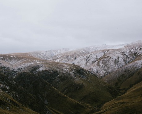
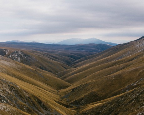
- The Southern Alps, best known for Mt. Cook, Mt. Aspiring, Queenstown, Wanaka, Helicopters, the Franz Josef Glacier, Bungee Jumping and Mordor, are remote and rugged, and perfectly suited to creative Overlanding. You see, it’s our contention that Overlanding is a lot like Skateboarding—as anybody who’s ever tried to heelflip a bench to pop-shovit to wallie a planter box to kickflip 5.0 a 12-stair handrail to 360 ollie off a curb into the street will tell you……you’ve got see it in your head first. And then, if you see you it hard enough, eventually you’ll make it.
- We knew a guy. And knowing a guy, especially a guy like the guy we knew, makes ALL THE DIFFERENCE to planning and coordinating a successful campaign. Side note: To be 100% accurate, we knew a woman, who knew a guy, about which guy she spoke VERY highly. But to be clear, we didn’t actually know the guy until she introduced us to the guy via email. And but even then, after three months of several dozen email threads featuring detailed plans and reports and contingencies and outlines and options regarding possible routes, in search of, the whole time, the “perfect” coast-to-coast trans-alps route, one that was ambitious-maybe-audacious, we hadn’t “all the way” met our guy. We had Skyped several times but, due to connectivity issues, audio only. Paul was probably was a real person. I mean, he had a website, we saw photos…….we emailed……
The Evolution of the Brodrick Pass Expedition in the form of a timeline featuring email highlights:
- 11/13/14 | Paul — “Rosara Joseph passed on your email as she thought I’d be interested in the guidebook project you are doing for Yonder. I can see something that includes wild beaches, glaciers, native bush, and alpine crossing, gold mining history, barren tors, kiwi farmland, a city (Dunedin) and finally out to a Gannet colony on a peninsula. It’d take in road, old goldmining tracks, native bushbashing, bike hauling, high country trails and lots of gravel.”
- 11/18/14 | Paul — “Any further south or north and you end up hitting 3000+m at either Mt Aspiring or Cook - not somewhere I’d want to try to take a bike! Need to avoid National Parks too - they really don’t like bikes in those. There’d be a fair bit of bike hauling, but there are also plenty of helicopters set up around there to help get over the real grunty bit. I’m not what you’d call a climber or alpinist for sure! Anyhow, crossing somewhere over there from the west coast glaciers ends up getting to Mt Pisa and the area inland of Cromwell - which is my favourite part of the world - all barren plateaus and gold mining remnants. There are a whole load of stories about the early kiwi pioneers who made the first crossings over that area (mostly in search of and finding fist-sized lumps of gold) - and even earlier Maori routes over the mountains.”
- 12/11/14 | Paul - “But that is messy and might take us a week of bashing through thick bush to get anywhere. Routes like that can be seriously impassable - and if we catch a rainy time (quite likely) the rivers will be brutal. Inland of there there are loads of great options - but they tend to follow a big loopy path - the ranges run north-south so travel east-west means days of big ups and downs. The whole thing - coast to Dunedin is probably a 10 day trip.”
- 1/3/15 / Paul — “We might have a route. Exciting! Now. Here’s another option that came up just yesterday. Mainly because the rafting people I was talking to will be down on the Landsborough at the right time and keen to help out. Note - the Broderick pass section will be tough going - but should be easy do-able from Ohau to Landsborough in 2 days. Dunedin (east coast). Taieri Gorge train to Pukerangi. Rock and Pillar Range to Naseby. Hawkdun Range to Omarama (high mountain doubletrack). Lake Ohau. Hiking route in to Brodrick Hut via Huxley. Over Brodrick Pass into the Landsborough River. Meet rafters at airstrip at the Landsborough and raft out towards highway 6. I reckon the heli could transport our bikes to the rafting get-out. It’ll be one day on an awesome remote NZ river.. Train out, then two days riding over the ranges to Ohau.”
- 1/14/15 | Paul — “The rafters have suggested 9th ties in with them. Which means us riding from 6th. Any chance you guys could make it a day earlier and we ride from 5th? I’ll get costs together. But it is looking awesome! We HAVE TO MAKE IT TO THE PUT-IN by the morning of the 9th. The whole ride depends on it. So we better build in some extra time just in case.”
The final route was settled. What made it possible was timing our crossing of the divide, the crux of our entire trip, Bordrick Pass, so that we’d meet a commercial outfitter on the far side, the Western Slope, of the Alps, at which point they’d float us out of the wilderness on the Landsborough and Haast Rivers until about 30k short of the coast, where we could pick-up trails again, and eventually paved roads. The plan was solid but;
- There are no roads on the western slope of the Alps in the area. So, the rafts and our guide, and all the other rafters/clients/guests would have to be helicoptered in.
- If the weather is bad, and the weather is often bad, helicopters can’t fly. If helicopters can’t fly, there is no way to get rafts to the put-in.
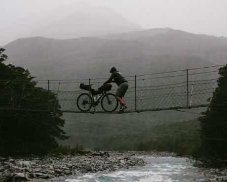
- The whole way from Dunedin to the crux of our route, Broderick Pass, we had roads, double track, trails and, at the very least, semi navigable river beds to follow. From the bottom of the East Slope of Broderick Pass to the top, the Pass itself, there was a very primitive semi-navigable bush trail to follow. Once over the top, down the West Slope, the trail became, allegedly, even less established. The point is, once over the Pass, the only way out, especially with bikes, was a raft. Once over the Pass, we were 100% committed.
- Because of that, possible weather, and the “timing” factor, the plan was to call the Rafting Outfitter the evening of the 8th to confirm everything.
- Spoiler Alert, on the evening of the 8th, we were unable to reach the Rafting Outfitter and, it turns out, it had nothing to do with the storm.
SECTION No2 Route Map
SECTION No3 FYI
- Put things in bags, keep things in bags, bags are your friends. Especially dry bags and ziplock bags.
- Use lightweight dry bags (Sea to Summit eVac) in place of “regular” nylon stuff sacks for electronics, clothing, sleeping bag, basically everything. A dry bag is mandatory for your sleeping bag.
- Separate food by meal by day. Pack each day separately but organize together, as a unit—smaller ziplock bags within larger ziplock bags.
- Pack all your camp clothes into one drybag.
- Keep bike tools in one bag.
- Like objects with like objects, store in a bag.
- Pack expecting wide temperature swings, we encountered snow, rain, and desert heat.
- Water is readily available on this route.
- Reprovisioning is available at the towns along the route.
SECTION No4 Bike Setup
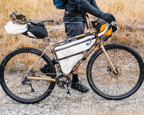
- 1. Fast on the roads
- 2. Comfortable all day
- 3. Climbs like a goat
- 4. Descends like a Peregrine falcon
- 1. Specialized Ground Control 2Bliss Ready
- 1. TRUST US!
- 1. Tape over them
- 2. Relieves wear and tear on the framebag
- 1. Excellent for light but bulky gear
- 2. Sleeping Bag
- 3. Clothes
- 4. Camp Shoes
- 1. Best for heavy and dense gear
- 2. Water
- 3. Food
- 4. Stove
- 5. Tools
- 1. PR MCA has great accessibility and a smaller zippered pouch
- 2. Best for frequently needed items and cylindrical stuff
- 3. Tent
- 4. Sleeping Pad
- 5. Clothing Layers
- 6. Snacks
- 7. Phone
- 8. Camera
SECTION No5
Basic Packing List Use this packing list as a baseline and modify to suit your needs.